DRONE PHOTOGRAPHY FOR
RV PARKS & MOBILE HOME
COMMUNITIES IN GAINESVILLE, FL
Aerial Photography, Cinematic Video & Due Diligence Surveys for RV Parks and Mobile Home Communities in Alachua County
WHY GAINESVILLE IS NORTH FLORIDA'S
MOST PARK-DENSE MARKET.
Gainesville sits at the geographic center of North Central Florida and anchors one of the most park-dense corridors in the entire state. Alachua County alone is home to at least seven campgrounds and RV parks, plus dozens of mobile home communities spanning the city, its surrounding suburbs, and the rural stretches along I-75 and US-441.
The combination of affordable land, proximity to the University of Florida, natural attractions like Paynes Prairie, the Santa Fe River, and Ichetucknee Springs, and steady year-round demand makes this one of the most resilient and competitive park markets in North Florida. For independent operators, that competition makes professional aerial photography a genuine business necessity — not a luxury.
For institutional investors, Alachua County and the surrounding North Central Florida corridor represent one of the most active manufactured housing acquisition markets in the state. The combination of University of Florida-driven rental demand, retiree population growth, and affordable land values has attracted significant private equity and REIT interest over the past several years.
- Paynes Prairie RV Park — Micanopy, FL
- Gainesville RV Resort — Gainesville, FL
- Santa Fe River Camp — High Springs, FL
- Alachua Pines Mobile Home Community — Alachua, FL
- Newberry Mobile Home Community — Newberry, FL
- Archer Mobile Home Park — Archer, FL
- Hawthorne Village MHC — Hawthorne, FL
- Waldo Road Mobile Home Park — Gainesville, FL
- University MHC — Gainesville, FL
- Pine Ridge Mobile Home Park — Gainesville, FL
AERIAL MARKETING THAT
FILLS YOUR SITES
AND ATTRACTS RESIDENTS.
Serving Independent RV Park Owners, Campground Operators & Mobile Home Community Managers in Gainesville and Alachua County
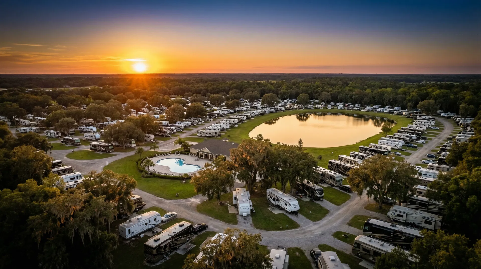
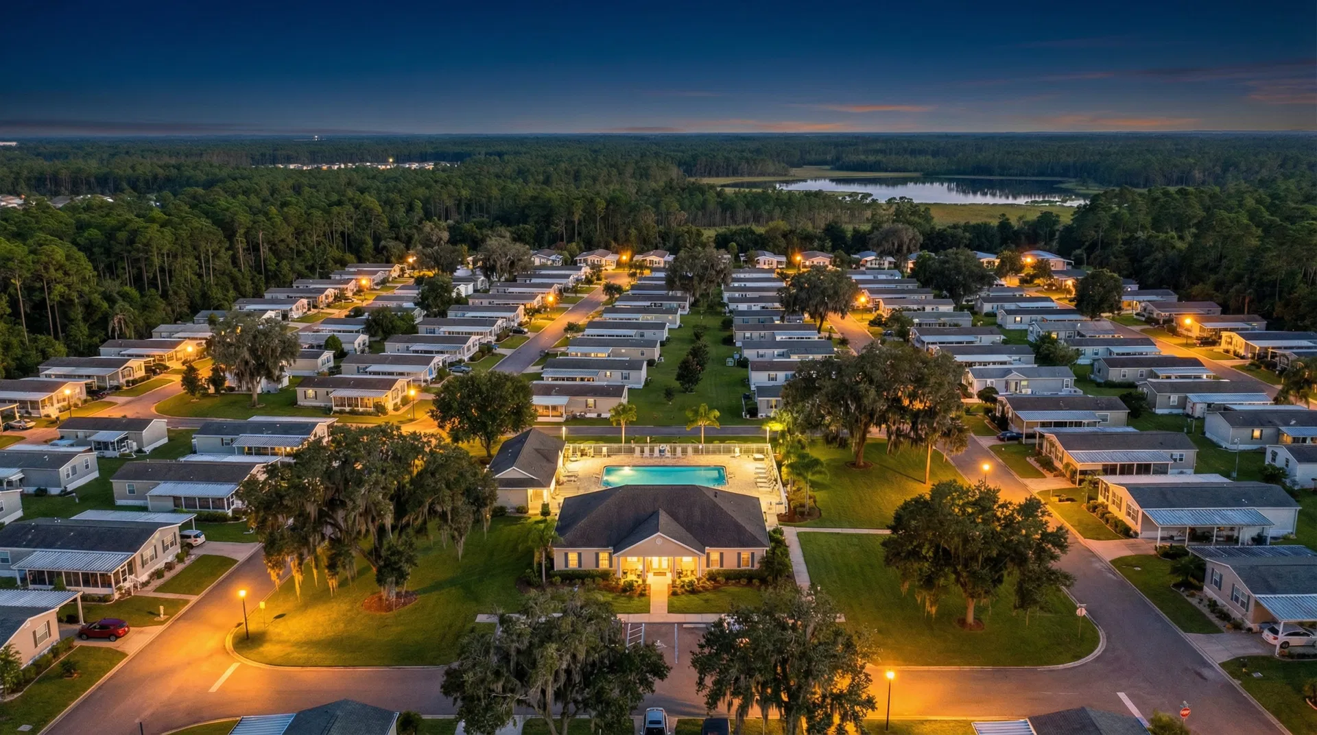
If you own or manage a mobile home park or RV resort in Gainesville, you already know that your competition is visible online — and that prospective guests and residents are making decisions based almost entirely on what they see in photos and videos before they ever pick up the phone. The parks that invest in professional aerial photography consistently outperform those that don't, because visual quality is the primary filter every prospective guest or resident applies when comparing options.
Park View Aerials works exclusively with mobile home parks and RV parks. That focus means we understand what makes your property compelling to prospective residents and guests. We know where to position the drone to capture the full lot layout. We know how to frame the entrance and amenities. We know what angles make a park look premium on Airbnb, RVshare, Hipcamp, and Google Maps. And because we're based in North Florida, we understand the seasonal look of properties in this region better than a national drone company ever could.
Stronger Online Listings: Replace blurry ground photos with crisp aerial imagery that stands out on every platform. See examples in our portfolio.
Social Media Content That Gets Shared: Short drone video clips of your park generate far more engagement than static images — ideal for Facebook, Instagram, and community groups.
Faster Occupancy: Prospective residents who see professional aerial imagery are more likely to visit and more likely to commit than those who view only ground-level photos.
Ground Tour Video Add-On: We drive through all accessible roads with a mounted camera for a $150 add-on that shows the street-level experience prospective guests want to see.
Documentation for Insurance & Resale: A complete aerial photo and video record of your property is invaluable when filing insurance claims after storms or preparing for a future sale.
AERIAL DOCUMENTATION FOR
CONSTRUCTION &
DEVELOPMENT TEAMS
Serving General Contractors, Site Developers & Project Managers Building or Renovating Parks in the Gainesville Area
If you're building, expanding, or renovating a mobile home community or RV park in Alachua County, drone documentation solves problems that ground-level photos can't. A scheduled aerial record gives your ownership group, lender, and project team a shared, timestamped view of site progress — without anyone driving to Gainesville for a walkthrough.
Pre-construction site surveys: Orthomosaic maps (GeoTIFF and GIS-ready) of the raw site for planning, earthwork estimation, and subdivision review.
Scheduled progress monitoring: Weekly, biweekly, or monthly flights during active construction, delivered as dated photo galleries with optional short-form video updates for draw requests and stakeholder reporting.
Milestone & completion documentation: As-built aerial photography for closeout packages, marketing handoff to the operator, and dispute protection.
We're FAA Part 107 certified, carry $2 million in commercial liability insurance, and can provide a certificate of insurance before mobilization — meeting standard vendor requirements for most GCs and owners' reps.
ENTERPRISE AERIAL INTELLIGENCE
FOR ACQUISITION, DUE DILIGENCE
& PORTFOLIO MANAGEMENT
Serving Private Equity Firms, REITs, Family Offices & Property Management Companies Operating in the North Florida Market
When your firm is evaluating a mobile home park or RV park acquisition in the Gainesville market, the quality of your property intelligence directly affects the quality of your decision. Traditional site inspections are slow, expensive, and inherently incomplete — they give you a ground-level view of a property that is best understood from above. Park View Aerials provides the aerial data, photography, and video documentation that institutional buyers and asset managers need to underwrite deals with confidence.
We are fully FAA Part 107 certified and carry $2 million in commercial liability insurance — meeting the standard requirements for vendor approval at most institutional platforms and property management companies. Our deliverables are provided in professional formats ready for inclusion in investment memos, due diligence packages, and lender presentations.
ALL DRONE SERVICES AVAILABLE
IN GAINESVILLE, FL
Every service listed below is available for properties in Gainesville and the surrounding Alachua County region. No travel surcharges apply within 100 miles. Contact us for a custom quote tailored to your property size and project scope.
Aerial Photography — Still Imaging
High-resolution aerial photos of your property captured with professional-grade drone cameras. Delivered as print-ready and web-optimized JPEGs. Ideal for listing platforms, your website, printed marketing materials, and social media. Multiple perspectives captured including overhead overview, oblique approach angles, amenity highlights, and lot-level detail.
Cinematic Video Production
Professionally edited drone video showcase of your property, complete with smooth flyover sequences, approach shots, and amenity coverage. Delivered as a 1–2 minute marketing video ready for YouTube, Facebook, your website, and listing platforms. Optional vertical cut for Instagram Reels and TikTok. Music-licensed, color-graded, and branded per your specifications.
Ground Tour Video — $150 Add-On
Camera-mounted vehicle drive-through of all accessible roads, capturing the street-level experience that prospective guests and residents want to see before visiting. Pairs perfectly with aerial packages for a complete property showcase. Especially effective for mobile home communities where road quality and neighborhood character are key selling points.
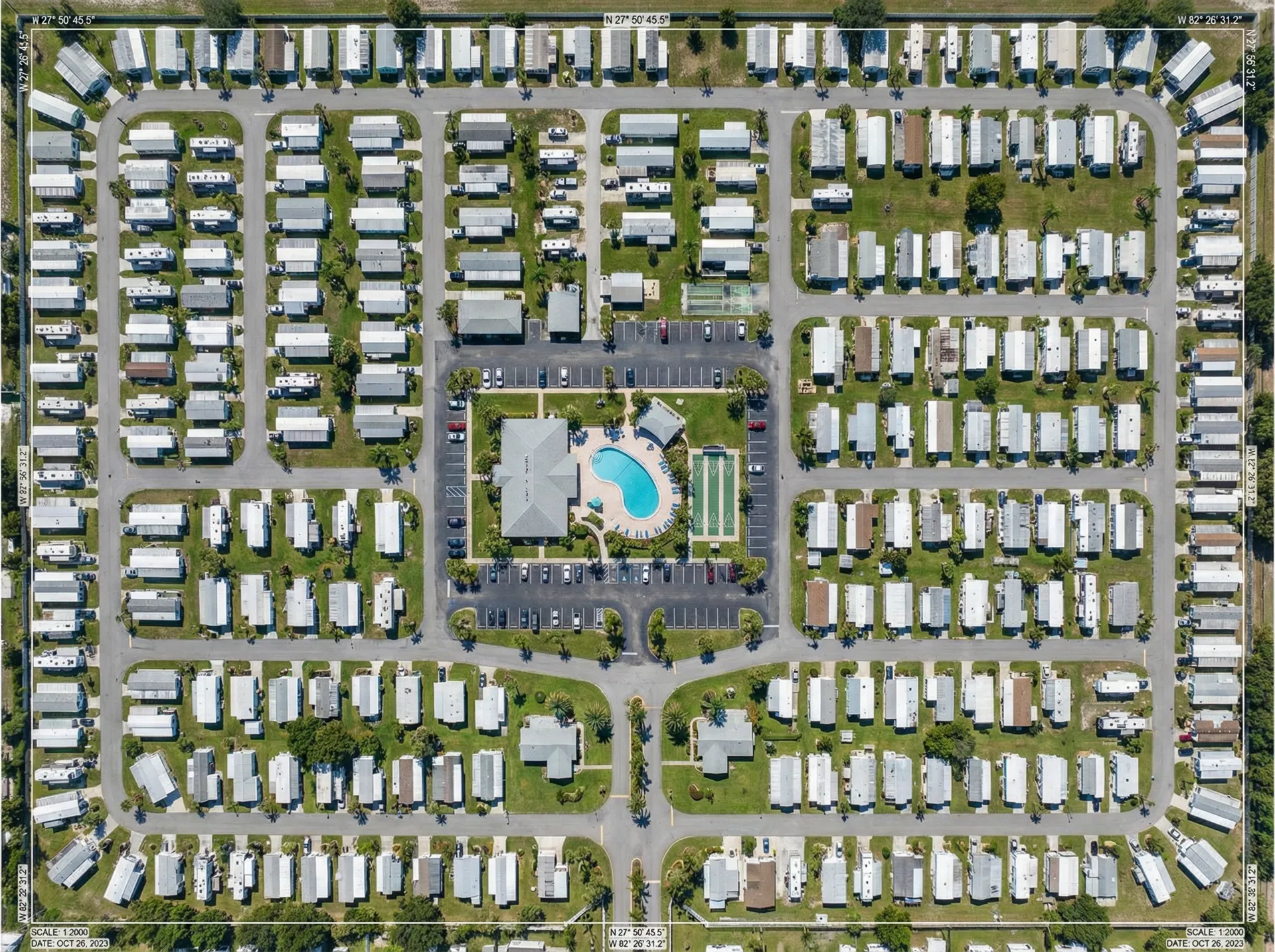
Orthomosaic Mapping & Aerial Surveys
High-accuracy composite aerial maps of your full property generated from overlapping drone imagery. GeoTIFF and standard image formats available. Suitable for lot count verification, site planning, GIS integration, and investor reporting. Recommended for properties larger than 10 acres or those undergoing subdivision review, rezoning, or sale preparation.
Acquisition Due Diligence Package
A comprehensive aerial documentation package designed for mobile home park and RV park acquisitions. Includes full-property photography, lot count verification imagery, infrastructure condition overview, environmental observation notes, and an organized deliverable folder suitable for inclusion in an investment memo or lender package. Typically completed within 5 business days of scheduling.
Insurance Documentation & Damage Assessment
Aerial photography specifically structured for insurance claims, including pre-storm/post-storm comparative documentation, roof and structure condition imagery, and comprehensive damage surveys. Useful both proactively (establishing a baseline record) and reactively (documenting damage for claims). Widely accepted by Florida-based insurers.
Construction & Renovation Progress Monitoring
Scheduled drone visits during active construction or park renovation projects. Provides ownership, lenders, and project managers with a timestamped visual record of progress. Available on weekly, biweekly, or monthly schedules. Deliverables include dated photo galleries and optional short-form video updates.
SIMPLE. FAST. PROFESSIONAL.
HERE'S WHAT TO EXPECT.
Get Your Free Quote
Submit a quote request online or call us at (352) 888-7627. Tell us your property address, what you need, and your timeline. We'll respond within a few hours — usually the same day.
We Schedule Your Flight
Once you approve the quote, we coordinate a flight window that works around your schedule and Florida's weather. We handle all FAA airspace notifications and clearances — you don't need to do anything except confirm the date.
We Capture Your Property
Our FAA-certified pilot arrives on time, flies the full scope of work, and captures everything needed for your package. Most residential-scale park shoots take 1–2 hours on site. We're professional, discreet, and cause minimal disruption to your residents or guests.
Receive Your Deliverables Within 24 Hours
Edited photos and video are delivered via a secure online link, organized and labeled. High-resolution files ready to use across every platform. If anything needs adjustment, we'll handle revisions quickly.
WHY AERIAL IMAGERY IS THE
HIGHEST-IMPACT MARKETING INVESTMENT
A PARK CAN MAKE
You Can't Show Scale from the Ground
Mobile home parks and RV resorts are spatial environments — their value lies in their layout, their lot size, their surrounding landscape, and the way the community is organized. None of that is visible from ground level. A drone shot at 200 feet shows a prospective guest or investor everything that matters: the full lot count, the amenities footprint, the proximity to natural features, and the overall character of the property in a single image.
Online Platforms Reward Better Visuals
Airbnb, Hipcamp, RVshare, and Google Maps all surface listings with higher-quality imagery more prominently in search results. Parks with professional aerial photography typically see higher click-through rates, more inquiries, and stronger booking conversion compared to parks with only ground-level photos.
Institutional Buyers Expect Aerial Documentation
In the current market for mobile home park and RV park acquisitions, sophisticated buyers and their lenders routinely require aerial documentation as part of the due diligence package. Properties that arrive at the table with professionally organized aerial surveys, orthomosaic maps, and condition documentation tend to move through the approval process faster and with fewer surprises.
Insurance Companies Value Proactive Records
Florida's insurance environment has made comprehensive property documentation more important than ever. Parks with a dated aerial photo library on file are in a significantly stronger position when filing post-storm or post-damage claims. Establishing that baseline record before you need it is one of the smartest low-cost risk management steps an owner can take.
WHAT OUR CLIENTS IN
NORTH FLORIDA SAY
"We had no idea how much better our park would look from the air. Within two weeks of updating our listing with Park View Aerials' photos, our inquiry rate nearly doubled. Best marketing spend we've made in years."
"Park View Aerials turned around our due diligence package in under 48 hours and the deliverables were organized exactly how our investment committee needed them. We'll be using them on every acquisition in the region going forward."
"Professional, on time, and the video they produced for our RV resort has been shared hundreds of times on Facebook. Our guests love it and it's brought in bookings from people who found us through the video."
FREQUENTLY ASKED QUESTIONS
ABOUT DRONE PHOTOGRAPHY
IN GAINESVILLE, FL
SERVING GAINESVILLE AND ALL SURROUNDING
COMMUNITIES IN NORTH CENTRAL FLORIDA
Park View Aerials provides drone photography and aerial services to mobile home parks and RV parks throughout the greater Gainesville area and surrounding counties. There are no travel surcharges for properties within 100 miles.
GET YOUR FREE
GAINESVILLE
QUOTE TODAY.
Whether you own a single RV park or manage a portfolio of mobile home communities across Alachua County, Park View Aerials delivers professional aerial photography and videography that drives real business results.
Response within 24 hours. No travel fees for Gainesville-area properties. FAA Part 107 certified and $2M insured.